Log In/Sign Up
Your email has been sent.
Federal Contract - Pending 1 Muirkirk Rd 0.25 - 2.96 Acres of Residential Land for Lease in Beltsville, MD 20705

HIGHLIGHTS
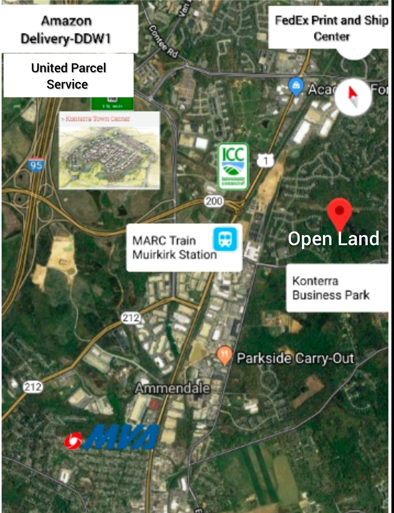
- Major Developing Area with Marc Train Commuter Transit
- High Elevation Midway point between BWI (17.1 Miles) and Reagan National (22.6 Miles) Airports
- Privately Owned by same Family since 1886
- Television/Radio/Radar Broadcast Rights with Naturally Graded Drainage
- 5 Miles to Washington, D.C., 25 Miles to Baltimore, MD., 24 Miles to Arlington, VA.
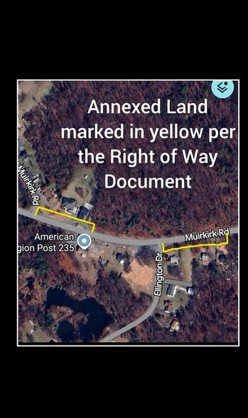
- Legal Documents show "Full Annexation" of all neighboring Residential Parcels adjacent to Development Grade Contiguous
LOT AVAILABLE
Display Rental Rate as
| Rental Rate |
|
Lot Size | 0.25 - 2.96 AC |
| Lease Term | 15 - 30 Years |
| Rental Rate | |
| Lease Term | 15 - 30 Years |
| Lot Size | 0.25 - 2.96 AC |
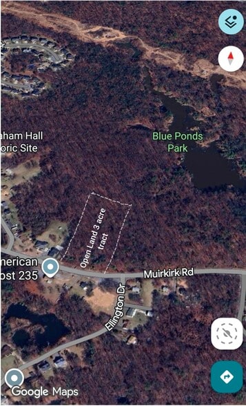
Option 1: Digital Frequency Rights Land total area specified for Television Broadcast Satellite Uplink/Downlink setup or Doppler Radar. "Special Note" The entire Residential area adjacent to this Land Parcel has been "Annexed", to shield any Development of the Land from Legal Claims and Challenges by Neighbors. Strips of Land, one 5ft wide and one 7ft wide representing the frontage of residential lots next to, and across the street from the Open Land 3 acre tract for Lease, are owned, and are a part of my Land Instrument. This claim is asserted by the "Right of Way" Document on Record, 2nd page. (Only the cover pages of the Land Instrument and Right of Way are posted on this Listing, qualified interested parties should have access to Land Records online to confirm).
"Contiguous Acres are also the Exclusive Jurisdiction of The United States of America" (Federal).

At an Elevation of 180ft above sea level, this location will provide Broadcasters and Wireless Providers the opportunity to Consolidate Phone Pole and Rooftop Leases to one Location within an 5 to 8 Mile radius, cutting Labor and Costs, such as Industry Average $2 Million Dollar Insurance Policies on each Site. Radio Broadcast antennas have a 40 Mile range, and Macrocell Antennas will reach over 10 Miles which is almost half of Washington,  D.C. (Average 98ft Elevation), with College Park, Riverdale, Hyattsville, and Brentwood in between. All of Laurel, Maryland (Average 160ft Elevation), would be covered as well which is a total potential Commercial and Residential Consumer Base reaching into the Millions. The Total Area will rent for $25,000.00/ monthly. Landowner will receive 25% Profit of Co-location agreements. Commercial Support Buildings can be constructed with Homestead Rights in place. Radio/Television Broadcast Towers are to be situated on the 2nd acre. In the event of any Federal Contracts that require direct dealings with the Land Owner, established escape clauses will be initiated and the Leaseholder will be duly compensated. Individual Ground Lease are not yet applicable, if that changes notifications will follow.
PROPERTY OVERVIEW
3 Acre tract of Wooded Open Land (Homestead Rights), Development Grade, Rural Residential, R32 Zoning (Elevator Rights), (Broadcast Rights) 180ft Elevation, On Grid, Private Sewer, Power, Water, Gas, Naturally Graded Drainage. "Raw Land", pre-construction "Right of Way", legally shielding Land Development of Contiguous Acres. Protected by Telecommunications Act Title 47 U.S. Code §332(B)
PROPERTY FACTS
| Total Space Available | 2.96 AC | Property Subtype | Residential |
| Min. Divisible | 0.25 AC | Proposed Use | Radio or Television Transmission Facility |
| Property Type | Land |
| Total Space Available | 2.96 AC |
| Min. Divisible | 0.25 AC |
| Property Type | Land |
| Property Subtype | Residential |
| Proposed Use | Radio or Television Transmission Facility |


1 of 9
VIDEOS
MATTERPORT 3D EXTERIOR
MATTERPORT 3D TOUR
PHOTOS
STREET VIEW
STREET
MAP
Presented by
Dereck Dodson Property
Federal Contract - Pending | 1 Muirkirk Rd
Already a member? Log In
Hmm, there seems to have been an error sending your message. Please try again.
Thanks! Your message was sent.