Your email has been sent.
277th Avenue - The Dewall Family Farm 41.3 Acres of Residential Land Offered at $1,672,770 CAD in Le Claire, IA 52753
Executive Summary
•Future development potential
•Excellent location near LeClaire, IA
•In close proximity to US -67 & I -80
•Productive tillable cropland
Property Facts
| Price | $1,672,770 CAD | Property Subtype | Residential |
| Sale Type | Investment or Owner User | Proposed Use | |
| No. Lots | 1 | Total Lot Size | 42.17 AC |
| Property Type | Land | ||
| Zoning | R-1 - Single-Family Residential | ||
| Price | $1,672,770 CAD |
| Sale Type | Investment or Owner User |
| No. Lots | 1 |
| Property Type | Land |
| Property Subtype | Residential |
| Proposed Use | |
| Total Lot Size | 42.17 AC |
| Zoning | R-1 - Single-Family Residential |
1 Lot Available
Lot
| Price | $1,672,770 CAD | Lot Size | 41.30 AC |
| Price Per AC | $40,502.91 CAD |
| Price | $1,672,770 CAD |
| Price Per AC | $40,502.91 CAD |
| Lot Size | 41.30 AC |
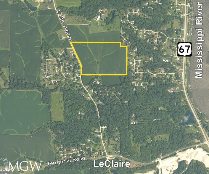
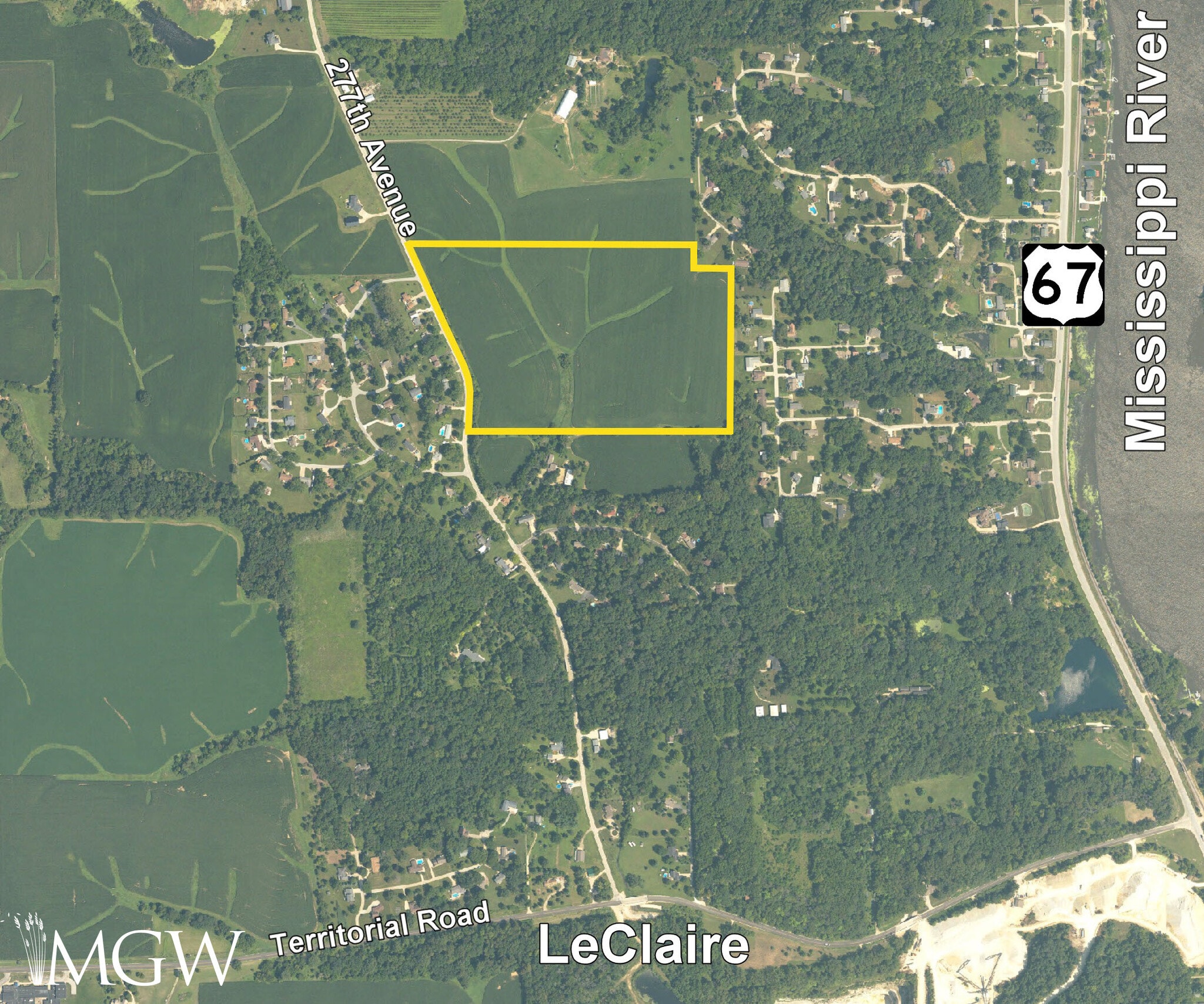
The farm's GPS coordinates are 41.623247, -90.361872, and can be copied and pasted into a mapping application for directions.
Description
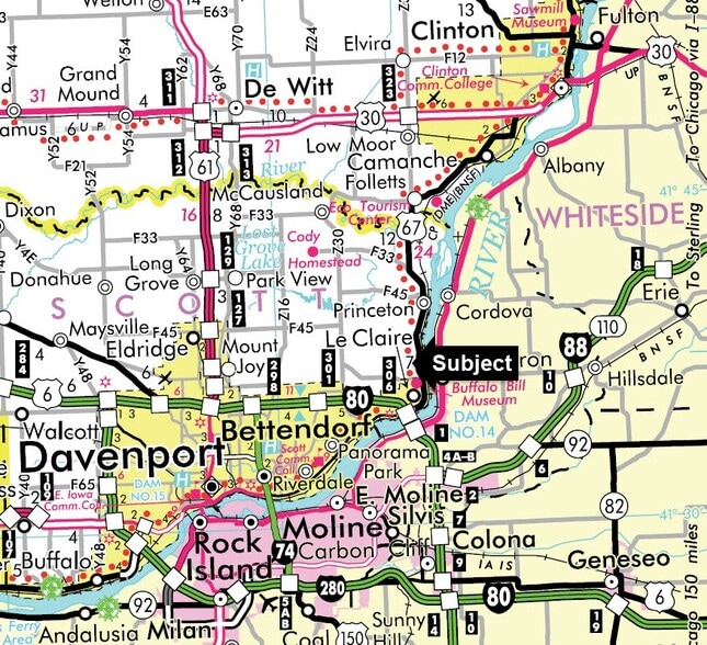
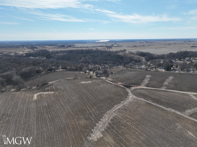
Location: The subject farm is located approximately 13 3/4 miles northeast of Quad Cities International Airport. Nearby cities include: LeClaire (1/2 mile south), Princton (2 1/4 miles north), and Bettendorf (3 3/4 miles southwest). Frontage: There is approximately 1/4 mile of road frontage on 277th Avenue. Major Highways: U.S. Route 67 is 3/8 mile east, Interstate 80 is 2 miles southwest, and U.S. Route 61 is 10 1/2 miles west of the property. Legal Description: A brief legal description indicates the property is located in Part of the Northeast Quarter of Section 27, Township 79 North – Range 5 East (LeClaire Township), Scott County, Iowa. Total Acres: There are a total of approximately 41.30 acres according to a survey. Tillable AcresThere are approximately 37.81 tillable acres, estimated. Soil Types: Major soil types found on this farm include Fayette silt loam and Fayette silty clay loam. The weighted average CSR2 is 58.1. Topography: The topography of the subject farm is nearly level to rolling. Mineral Rights: All mineral rights owned by the seller will be transferred in their entirety to the new owner. Possession: Possession will be given at closing, subject to the terms and conditions set forth in a purchase contract. Price Terms: The asking price is $29,500 per acre. A 10% earnest money deposit should accompany any offer to purchase. Financing: Mortgage financing is available from several sources. Names and addresses will be provided upon request. Taxes: The 2024 net taxes, payable in 2025 and 2026, totaled $998.00. The gross taxes for that period totaled $1,050.97. The tax parcel number is 952721002. Grain Markets: There are a number of grain markets located within 15 miles of The Dewall Family Farm. Zoning: The property is zoned R-1: Single-Family Residential.
Property Taxes
| Parcel Number | 952721002 | Improvements Assessment | $0 CAD |
| Land Assessment | $108,740 CAD | Total Assessment | $108,740 CAD |
Property Taxes

Presented by

277th Avenue - The Dewall Family Farm
Hmm, there seems to have been an error sending your message. Please try again.
Thanks! Your message was sent.