Your email has been sent.
Bayou Steele Rd @ Hwy 628 Rd
Laplace, LA 70068
Batture Land bet. Hwy 628 & Mississippi River · Land For Sale
·
7.60 AC
Executive Summary
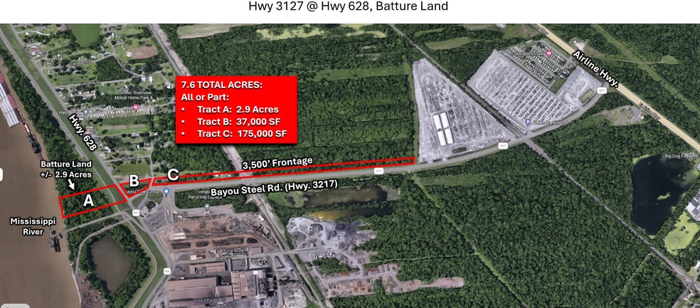
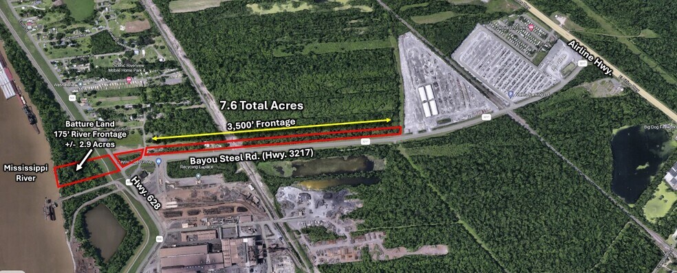
A total of +/- 7.6 Acres available in St. John the Baptist Parish.
Of which, +/- 2.9 Acres is Batture land (Tract A) located between Hwy 628 and the Mississippi River. It's value consists of 175' River Frontage. The Middle section (Tract B) is approximately 175' wide along Hwy 628 & 50' wide on Bayou Steel Rd. (Hwy. 3217) between Hwy. 628 and Garden Grove Street. This corner lot area measures approximately 37,000 SF. The Easternmost section (Tract C) is a 50' wide section along Bayou Steel Rd. (Hwy 3217) on either side of the railroad with approximately 3,500 feet frontage.
None of the property is indicated as in the "Flood Zone"
+/- 7.6 TOTAL ACRES: ($225,000)
Located in John the Baptist Parish
All or Part:
Tract A: ($90,000)
+/- 2.9 Acres
Batture Land between Hwy. 628 and the Mississippi River
Approx. 175' River Frontage
Tract B: ($75,000)
+/- 37,000 SF
Corner of Hwy. 628 & and Bayou Steel Rd. (Hwy. 3217)
+/- 580' Hwy. 628 Frontage & +/- 325' Bayou Steel Frontage
Flood Zone "X"
Tract C: ($60,000)
+/- 175,000 SF
+/- 3,500' Bayou Steel Frontage
Flood Zone "X"
Property Facts
| Sale Type | Investment or Owner User | Property Subtype | Commercial |
| No. Lots | 1 | Proposed Use | Commercial |
| Property Type | Land | Total Lot Size | 7.60 AC |
| Zoning | C-2 - Commercial | ||
| Sale Type | Investment or Owner User |
| No. Lots | 1 |
| Property Type | Land |
| Property Subtype | Commercial |
| Proposed Use | Commercial |
| Total Lot Size | 7.60 AC |
| Zoning | C-2 - Commercial |
1 Lot Available
Lot
| Price | $306,070 CAD | Lot Size | 7.60 AC |
| Price Per AC | $40,272.33 CAD |
| Price | $306,070 CAD |
| Price Per AC | $40,272.33 CAD |
| Lot Size | 7.60 AC |
Batture Property Bayou Steel Rd @ Hwy 628
Description
Batture Property Bayou Steel Rd @ Hwy 628 Property Profile: A total of +/- 7.6 Acres available in St. John the Baptist Parish. Of which, +/- 2.9 Acres is Batture land. 1.) Batture property located between Hwy 628 and the Mississippi River. The Batture Property (+/- 2.9 Acres) value consists of river frontage: approximately 175' 2.) (Middle section) Approximately 175' wide at Hwy 628; 50' wide section between Garden Grove Street and the railroad. This corner lot area measures approximately 37,000 SF. 3.) (Easternmost section) 50' wide section along Hwy 3127 east of the railroad.) The property along Hwy 3217 which is 50' wide and approximately 3,500 feet frontage None of the property is indicated as in the "Flood Zone".
