Your email has been sent.
Dateland 172
Dateland, AZ 85333
Land For Sale
·
172.70 AC

Investment Highlights
- Prominent frontage on Interstate 8 offering excellent regional visibility
- Flexible RA-40 zoning suitable for agriculture, development, or energy-related uses
- Dual-sided positioning along both north and south sides of the interstate at Ave 63 E
- Low annual property tax basis supporting long-term investment holding
Executive Summary
Zoned RA-40, the site delivers flexibility for agricultural production, low-density development, or forward-looking land banking. Its expansive acreage and dual-sided interstate frontage create a versatile canvas for owners seeking both present utility and future upside. Investors will appreciate the property’s low annual tax basis paired with its straightforward configuration, making underwriting and long-term planning efficient and predictable.
The Dateland area has benefited from its strategic location between Yuma and Phoenix, both key economic anchors for transportation, military, logistics, and agricultural industries. Yuma County continues to attract interest from renewable energy groups, agricultural operators, and industrial developers pursuing large-format land positions with reliable access and favorable regulatory structures. The property’s positioning allows an owner to capitalize on this sustained regional momentum.
Whether held for phased development, agricultural applications, or future energy infrastructure, Dateland 172 stands out as a compelling acquisition anchored by scale, access, and regional growth potential. Its placement along Interstate 8 provides a prominent regional presence with long-term strategic value. With limited large-acre opportunities of this nature available along major corridors, this property offers an exceptional chance to secure a versatile and well-located land asset in one of Arizona’s most steadily evolving counties.
Property Facts
| Sale Type | Investment | Proposed Use | Commercial |
| No. Lots | 1 | Total Lot Size | 172.70 AC |
| Property Type | Land | Opportunity Zone |
Yes
|
| Property Subtype | Commercial | ||
| Zoning | RA-30 - Rural | ||
| Sale Type | Investment |
| No. Lots | 1 |
| Property Type | Land |
| Property Subtype | Commercial |
| Proposed Use | Commercial |
| Total Lot Size | 172.70 AC |
| Opportunity Zone |
Yes |
| Zoning | RA-30 - Rural |
1 Lot Available
Lot
| Price | $939,811 CAD | Lot Size | 172.70 AC |
| Price Per AC | $5,441.87 CAD |
| Price | $939,811 CAD |
| Price Per AC | $5,441.87 CAD |
| Lot Size | 172.70 AC |
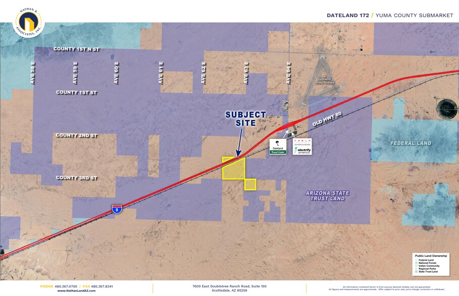
Prime ±172.70 acre parcel spanning both sides of Interstate 8 at Ave 63 E in Dateland. Zoned RA 40 with excellent visibility and strong investment or development potential.
Description
The property known as Dateland 172 consists of approximately 172.70 acres located in Yuma County, Arizona. It is positioned on both the north and south sides of Interstate 8 at Avenue 63 East, placing the acreage directly adjacent to the interstate corridor within the Dateland area. The land is divided into two assessor-identified parcels, referenced in county records as APNs 208-67-002 and 208-63-008. The surrounding landscape is characteristic of the broader region, with open desert terrain, expansive views, and sparse development in the immediate vicinity. Interstate 8 provides the most prominent physical landmark and the primary point of recognition for orientation. The property’s placement along both sides of the highway offers visibility to eastbound and westbound traffic, and the open nature of the land provides an unobstructed sense of scale across the site. [attachment...104915.343 | PDF] Zoning for the acreage is classified as RA-40 under Yuma County jurisdiction. This rural agricultural designation reflects the area’s established land-use patterns and allows for low-density rural activities consistent with the region’s desert environment. The zoning also helps define setbacks, allowable uses, and developmental parameters. The property is accessed through local desert roadways that intersect with Interstate 8 via Avenue 63 East. The land itself is largely undeveloped, without documented structural improvements or built features in the material provided. Its configuration spans both sides of the interstate, giving it a distinctive geographic footprint compared to single-contiguous-side parcels. Annual property taxes for the most recent assessment year documented are $566.64, reflecting the rural and unimproved nature of the site. Overall, the acreage represents a sizable tract within a remote portion of Yuma County defined by highway adjacency, open desert conditions, and agricultural-oriented zoning.
Property Taxes
| Parcel Numbers | Improvements Assessment | $0 CAD | |
| Land Assessment | $6,425 CAD | Total Assessment | $6,425 CAD |
Property Taxes
