Your email has been sent.
Sam Jones rd - 623 AC | Data Center Use 623 Acres of Industrial Land in Atmore, AL 36502

Investment Highlights
- 115 KV Alabama Power transmission on-site
- Gas pipeline ~1.5 mi · I-65 ~6 mi
- Two adjacent in-service substations
Executive Summary
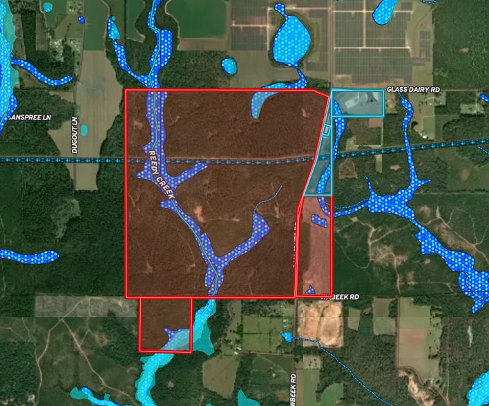
Rare 623-acre development-grade parcel in Escambia County, Alabama, positioned in the rural corridor between Atmore (approximately 7.5 miles west-northwest) and I-65 Exit 57 (approximately 6 miles northeast). The site sits at the intersection of the three inputs that matter most for hyperscale data center and utility-scale battery storage development: in-corridor high-voltage transmission, adjacent grid-tie infrastructure, and proximate interstate gas pipeline supply.
POWER INFRASTRUCTURE
• 115 KV Alabama Power transmission runs directly through the property — multiple in-service segments, AC overhead, with redundant routing
• Two adjacent substations directly east of the parcel at 31.00965, -87.36135 — associated with the East Atmore Solar project (80 MW PV development on the adjoining 500-acre site); operational status to be confirmed with current owner and Alabama Power
• East Atmore Solar originally developed by Pine Gate Renewables (Asheville, NC); acquired by Nofar USA in January 2026 via Pine Gate's bankruptcy proceedings
• Multiple 115 KV tap points along the corridor
• Backbone owned and operated by Alabama Power Co., a Southern Company subsidiary (NYSE: SO)
• Large-load interconnection inquiries welcomed directly through Alabama Power for qualifying data-center loads
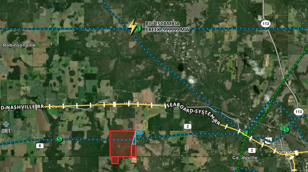
• Plant Barry (3,246 MW, coal + gas, Alabama Power) approximately 38 miles west
GRID POSITION
• NERC SERC reliability region · Southern Company (SOCO) balancing authority
• Outside ERCOT / PJM congestion exposure — vertically-integrated regulated utility environment with historically high reserve margins
• Alabama generator interconnection queue currently reflects approximately 18 GW of active projects (5.1 GW solar / 3.5 GW hybrid / 1.25 GW storage / 8.2 GW gas — SREA Fall 2025 update)
NATURAL GAS
• Interstate natural gas transmission pipeline corridor approximately 1.5 miles from the property — supports on-site combined-cycle, peaker, cogeneration, or thermal cooling installations
• Big Escambia Creek natural gas processing and treating plant approximately 4 miles north — operating facility run by Escambia Operating Co. LLC (legacy ExxonMobil sour-gas play, NAICS 211130)
• Major corridor operators in region include Gulf South Pipeline, Southeast Supply Header, Florida Gas Transmission, and Gulfstream Natural Gas System — buyer to confirm specific operator via PHMSA NPMS
LOCATION & ACCESS
• Approximately 7.5 miles east-southeast of downtown Atmore in the rural Atmore / Canoe / Gandyville corridor
• I-65 Exit 57 (AL-21 interchange) approximately 6 miles from the property — direct access to Mobile (south) and Montgomery (north)
• US-31 and the CSX Seaboard System rail line traverse the corridor immediately north of the parcel
• ~51 miles to Mobile, AL · Port of Mobile · University of South Alabama · Mobile Regional Airport
• ~49 miles to Pensacola, FL · NAS Pensacola · Pensacola International Airport
• Atmore Industrial Park and Rivercane (AdvantageSite-certified 740-acre mixed-use district at Exit 57) demonstrate the corridor's active development trajectory
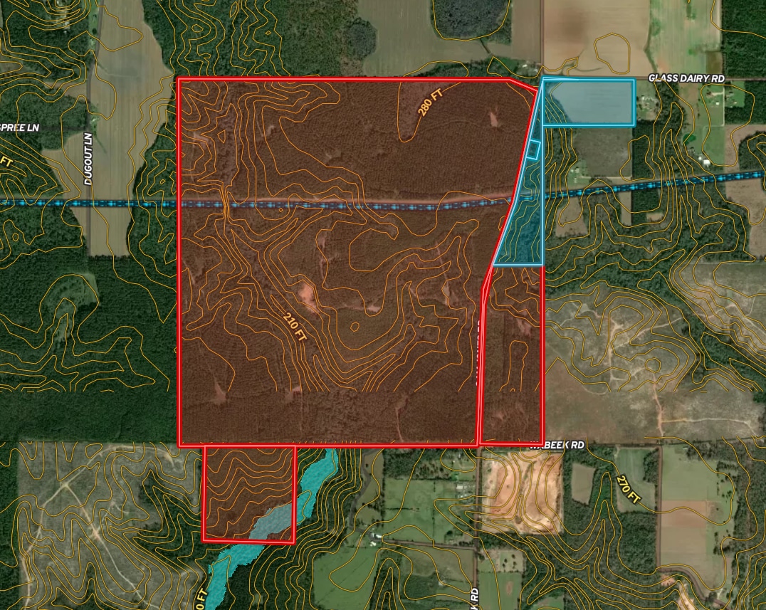
SITE CHARACTERISTICS
• Greenfield · gently sloping upland · approximately 210–280 ft AMSL
• Reedy Creek crosses the western portion; majority of parcel is upland and outside FEMA-mapped floodplain (site-specific Flood Elevation Certificate recommended)
• Outside municipal limits — flexible permitting environment (zoning to be verified with Escambia County)
• Coastal Alabama Community College (Atmore campus) and Atmore Community Hospital in the region
CONNECTIVITY
• Multi-carrier fiber available in the Atmore area — AT&T Fiber, Mediacom Business, C Spire Fiber, Frontier Communications
• Gigabit+ symmetric service available; address-specific availability to be confirmed via FCC National Broadband Map
• Regional long-haul fiber routes along I-65 and the CSX rail corridor
INCENTIVES
• Alabama Jobs Act — performance-based Jobs Credit + Investment Credit
• AL Data Processing Center Sales & Use Tax Abatement (AL Code §40-9B et seq.) — long-term abatements available on qualifying equipment (HB 399 of 2026 limits new abatements to 20 years for projects =$200M / =100 MW; buyer to confirm current law)
• Long-term Alabama property tax abatement available for qualifying capital investment
• AIDT — free, top-rated workforce training through the Alabama Community College System
• SEEDS Act site-readiness funding has reached Escambia County projects
• Right-to-work state · pro-business legislature and Public Service Commission
OFFERED BY ARTEMIS COMMERCIAL GROUP
National site-selection and energy land specialists.
Offered in association with Scott Reid, ParaSell, Inc., Licensed Alabama Broker #000127148-0.
All information deemed reliable but not guaranteed. Buyer to verify independently. Pricing available upon request.
Property Facts
1 Lot Available
Lot 3
| Lot Size | 623.00 AC |
| Lot Size | 623.00 AC |
623 AC greenfield site between Atmore and I-65 Exit 57, Escambia Co AL. 115 KV Alabama Power transmission on-site, two adjacent substations tied to East Atmore Solar (80 MW). Gas pipeline ~1.5 mi, Big Escambia Creek gas plant ~4 mi N.
Description
A 623-acre greenfield development site in unincorporated Escambia County, Alabama, positioned in the rural corridor between downtown Atmore (approximately 7.5 miles to the west-northwest) and I-65 Exit 57 (approximately 6 miles to the northeast). The property's defining feature is its energy infrastructure: 115 KV Alabama Power transmission lines run directly across the parcel with multiple in-service segments and redundant routing options. Adjacent grid-tie infrastructure. Two substations sit immediately east of the property line at 31.00965, -87.36135, associated with the East Atmore Solar project — an 80 MW PV development on the adjoining 500-acre site. The solar project was originally developed by Pine Gate Renewables (Asheville, NC) and was acquired by Nofar USA in January 2026 via Pine Gate's bankruptcy proceedings. Substation operational status and energization date should be confirmed with the current project owner and Alabama Power. The presence of adjacent grid-tie infrastructure is a meaningful credibility signal — it demonstrates that Alabama Power has been willing to support new interconnection at this exact location, and it potentially opens creative deal structures for a data center developer such as behind-the-meter PPAs, shared infrastructure, or co-location discussions with the solar operator. Grid position. The site is within the Southern Company (SOCO) balancing authority and NERC SERC reliability region — a stable, vertically-integrated regulated utility environment outside ERCOT and PJM congestion zones, with historically high reserve margins. Alabama Power Co. (a Southern Company subsidiary, NYSE: SO) accepts large-load interconnection inquiries directly for qualifying data-center loads. The Plant Barry generating complex (3,246 MW, coal + gas) sits approximately 38 miles west. Alabama's active generator interconnection queue currently reflects roughly 18 GW across solar, hybrid, storage, and gas projects (SREA Fall 2025 update). Gas supply within reach. An interstate natural gas transmission pipeline corridor runs approximately 1.5 miles from the property — sufficient proximity to support on-site combined-cycle, peaker, cogeneration, or thermal cooling installations. The Big Escambia Creek natural gas processing and treating plant (operator: Escambia Operating Co. LLC; legacy ExxonMobil sour-gas play; NAICS 211130) sits approximately 4 miles north and anchors the region's legacy gas infrastructure. Major corridor operators include Gulf South Pipeline, Southeast Supply Header, Florida Gas Transmission, and Gulfstream Natural Gas System. Transportation and corridor context. The CSX Seaboard System rail line and US-31 run immediately north of the parcel. I-65 access via Exit 57 is approximately 6 miles away, putting Mobile (~51 miles) and Pensacola (~49 miles) within easy reach. Montgomery is approximately 135 miles north via I-65. The Port of Mobile, Mobile Regional Airport, Pensacola International Airport, and NAS Pensacola all serve the broader region. Site characteristics. Topographically, the parcel is upland and gently sloping at approximately 210–280 ft AMSL — favorable for a level development pad. Reedy Creek traverses the western portion of the property; most of the parcel is upland and outside FEMA-mapped floodplain, though buyers should obtain a site-specific Flood Elevation Certificate. The parcel sits outside municipal limits in unincorporated Escambia County, supporting a flexible permitting environment (zoning to be verified with the county before development). Connectivity. Multi-carrier fiber is available in the Atmore area: AT&T Fiber, Mediacom Business, C Spire Fiber, and Frontier Communications. Long-haul fiber routes follow the I-65 and CSX rail corridors. Gigabit+ symmetric service is available in the region; address-specific availability should be confirmed via the FCC National Broadband Map. Incentives. The site qualifies for a strong suite of Alabama incentives: the Alabama Jobs Act (Jobs Credit + Investment Credit), the Alabama Data Processing Center Sales & Use Tax Abatement under AL Code §40-9B, long-term property tax abatements, AIDT (free, top-rated workforce training through the Alabama Community College System), and access to SEEDS Act site-readiness funding. Note: Alabama HB 399 (2026) limits new data center abatements to 20 years for projects =$200M or =100 MW; buyers should confirm current law before relying on any specific abatement term. Workforce and local support. Alabama is a right-to-work state. Local development support is available through the Escambia County Industrial Development Authority (406 S Trammell St, Atmore; (251) 368-5404). Coastal Alabama Community College's Atmore campus and Atmore Community Hospital serve the region. The Atmore Industrial Park and Rivercane (AdvantageSite-certified 740-acre mixed-use district at Exit 57) demonstrate the corridor's active development trajectory. Offered for sale by Artemis Commercial Group in association with Scott Reid, ParaSell, Inc., Licensed Alabama Broker #000127148-0. Pricing available upon request. All information is deemed reliable but not guaranteed; buyer to verify independently.


Property Taxes
| Parcel Number | 25-08-33-0-000-001.001 | Improvements Assessment | $0 CAD |
| Land Assessment | $0 CAD | Total Assessment | $58,226 CAD |
Property Taxes

Presented by

Sam Jones rd - 623 AC | Data Center Use
Hmm, there seems to have been an error sending your message. Please try again.
Thanks! Your message was sent.