Log In/Sign Up
Your email has been sent.

The Meer 0.61 Acres of Commercial Land in Benson OX10 6GG


Investment Highlights
- Strategically positioned land
- Great transport connections
- Situated on the northern edge of the popular village of Benson
Executive Summary
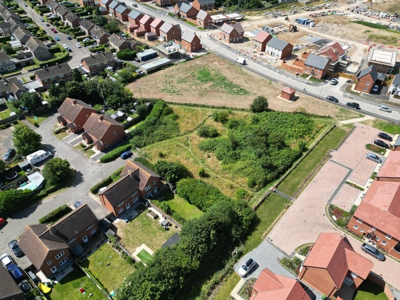
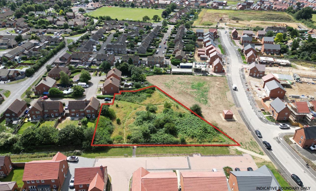
LAND SITUATED IN A STRATEGIC POSITION ON THE EDGE OF THE POPULAR SETTLEMENT OF BENSON TO THE SOUTHEAST OF OXFORD EXTENDING TO APPROXIMATELY 0.61 ACRES (0.25 HECTARES) LOCATION The property is situated on the northern edge of the popular village of Benson, within the administration of South Oxfordshire District Council, with frontage onto the B4009 via 'The Meer' from which access is provided. Benson is an attractive Oxfordshire village positioned adjacent to the River Thames and located approximately 11 miles southeast of Oxford and approximately 6 miles east of Didcot. Oxford is a regional city hub providing an extensive range of services and facilities including shops, restaurants, banks, sports centre, retail parks and supermarkets. Facilities in Benson include a Co-op groceries store, Pharmacy, Vet, Community Hall, Primary School, Recreation Ground, public houses and a post office. PROPERTY The Property is a triangular shaped parcel of land, extending to approximately 0.61 acres (0.25 hectares) comprising of predominantly grassland with some scrub vegetation. The Property is bound to the north, east and western boundaries by a new residential development, known as 'Chilton Grange'. The southern boundary adjoins existing residential properties to the south and provides access to the highway via 'The Meer'. PLANNING The Local Planning Authority is South Oxfordshire District Council. The Benson Neighbourhood Development Plan Review was made (adopted) as part of the district council's development plan on 14 March 2023 and identifies the property as a possible location for residential development, although the site is not allocated in the South Oxfordshire Local Plan 2035. An application (reference P04/E0285) for the erection of 8 dwellings, vehicular access and associated parking was submitted in 2004, but was withdrawn prior to determination in 2007. There have been no further known planning applications made. REGISTERED TITLE The land is registered with the Land Registry under Title Number ON9165. Please note that the existing Land Registry title plan includes land that is no longer within the Vendor's ownership. METHOD OF SALE The opportunity is offered for sale freehold. We will be monitoring interest through the marketing period with a view to setting a deadline for bids. It is therefore recommended that prospective purchasers wait to receive further instructions from Carter Jonas before coming forward with any offer. Offers are invited both on subject to planning and on an unconditional basis. The vendors will also consider overage proposals. LOCAL AUTHORITY South Oxfordshire District Council (https://www.southoxon.gov.uk/) RIGHTS OF WAY, EASEMENTS AND COVENANTS The land is subject to public footpath rights of way aligned along the eastern and western boundaries under footpaths reference numbers 125/11/20 and 125/12/10. SERVICES There are no known services currently available on the site. FURTHER INFORMATION An Information Pack has been prepared to accompany these particulars which includes title information. This is available upon request and prospective purchasers should note that the vendors will expect them to have obtained and carefully considered the contents of the Information Pack prior to submitting an offer. For further information or to receive the Information Pack, please contact Carter Jonas. VIEWING The property may be viewed from the highway. Parties wishing to walk the property should arrange an appointment with Carter Jonas.
Property Facts
| Sale Type | Investment | Property Type | Land |
| Tenure | Freehold | Property Subtype | Commercial |
| No. Lots | 1 | Total Lot Size | 0.61 AC |
| Sale Type | Investment |
| Tenure | Freehold |
| No. Lots | 1 |
| Property Type | Land |
| Property Subtype | Commercial |
| Total Lot Size | 0.61 AC |
1 Lot Available
Lot
| Lot Size | 0.61 AC |
| Lot Size | 0.61 AC |
The property is a triangular shaped parcel of land, extending to approximately 0.61 acres (0.25 hectares) comprising of predominantly grassland with some scrub vegetation.
Description
The property is a triangular shaped parcel of land, extending to approximately 0.61 acres (0.25 hectares) comprising of predominantly grassland with some scrub vegetation. The property is situated on the northern edge of the popular village of Benson, within the administration of South Oxfordshire District Council, with frontage onto the B4009 via 'The Meer' from which access is provided.
1 1

1 of 10
Videos
Matterport 3D Exterior
Matterport 3D Tour
Photos
Street View
Street
Map
1 of 1
Presented by
The Meer
Already a member? Log In
Hmm, there seems to have been an error sending your message. Please try again.
Thanks! Your message was sent.