Log In/Sign Up
Your email has been sent.
W 83rd St
De Soto, KS 66018
N & E of W. 82nd St. & Valley Spring Dr. · Land For Sale
·
36.16 AC
Investment Highlights
- Located on the south side of the BNSF railroad and Kansas River
- Close proximity to downtown De Soto
- Located in the highly acclaimed De Soto School District
- De Soto has the advantages of a Johnson County location with small town benefits
- Great access to K-10 Highway
- Site is divisible
Executive Summary
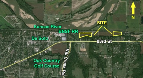
34043 - De Soto has an abundance of recreational activities, beautiful neighborhoods, has a low cost of living, all while enjoying a small town atmosphere while being close to big city amenities. Located off of K-10 Highway, the KC Metro area is easily accessible. This property consists of 18.08+/- acres zoned for Industrial use. Located on the south side of the Kansas River and BNSF Railroad, the site is divisible. The entire site is located in the 100 year floodplain.
N & E of W. 82nd St. & Valley Spring Dr.
N & E of W. 82nd St. & Valley Spring Dr.
Property Facts
| Sale Type | Investment | Proposed Use | Single Family Development |
| No. Lots | 3 | Total Lot Size | 36.16 AC |
| Property Type | Land | No. Stories | 1 |
| Property Subtype | Residential | Cross Streets | Valley Spring Dr. |
| Zoning | R-1 - Residential | ||
| Sale Type | Investment |
| No. Lots | 3 |
| Property Type | Land |
| Property Subtype | Residential |
| Proposed Use | Single Family Development |
| Total Lot Size | 36.16 AC |
| No. Stories | 1 |
| Cross Streets | Valley Spring Dr. |
| Zoning | R-1 - Residential |
3 Lots Available
Lot
| Price | $372,352 CAD | Lot Size | 18.08 AC |
| Price Per AC | $20,594.70 CAD |
| Price | $372,352 CAD |
| Price Per AC | $20,594.70 CAD |
| Lot Size | 18.08 AC |
Lot
| Price | $223,864 CAD | Lot Size | 10.87 AC |
| Price Per AC | $20,594.70 CAD |
| Price | $223,864 CAD |
| Price Per AC | $20,594.70 CAD |
| Lot Size | 10.87 AC |
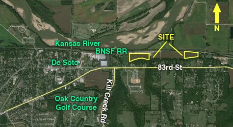
53903 - This property consists of 10.87+/- acres zoned for Industrial use and is located on the south side of the Kansas River and BNSF Railroad. The entire site is located within the 100 year floodplain.
Lot
| Price | $148,488 CAD | Lot Size | 7.21 AC |
| Price Per AC | $20,594.70 CAD |
| Price | $148,488 CAD |
| Price Per AC | $20,594.70 CAD |
| Lot Size | 7.21 AC |
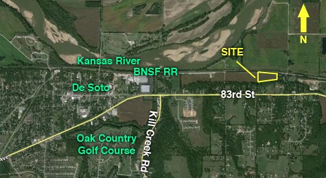
53913 - This property consists of 7.21+/- acres zoned for Industrial use and is located on the south side of the Kansas River and BNSF Railroad. The entire site is located within the 100 year floodplain.
Property Taxes
| Parcel Number | AF221227-3004 | Improvements Assessment | $0 CAD |
| Land Assessment | $1,079 CAD | Total Assessment | $1,079 CAD |
Property Taxes
Parcel Number
AF221227-3004
Land Assessment
$1,079 CAD
Improvements Assessment
$0 CAD
Total Assessment
$1,079 CAD
1 of 4
Videos
Matterport 3D Exterior
Matterport 3D Tour
Photos
Street View
Street
Map