Se Connecter/S’inscrire
Votre courriel a été envoyé.

3801 La Cienega Blvd - ±2.24-Acre Residential Development Site Lot • Résidentiel • 2,24 Acres • 16 820 400 $ CAD • Culver City, CA 90232
Certaines informations ont été traduites automatiquement.
Faits saillants de l'investissement
- ±2.24-Acre Residential Development Site in a Prime Culver City Location
- General Plan Land Use is Medium Density Multifamily (Up to 50 du/acre)
- ±1.02 Acres of the Site is Located within an Earthquake Fault Zone (No Build Area
- Zoning is PD-14 (Planned District)
- Culver City Ordinance No. 2016-007 allows for the Development of a 90-unit/100-bed Senior Care Facility on the Site
- ±1.22 Acres of the Site is Located Outside of the Fault Zone is Fully Developable Land
Résumé de l'annonce
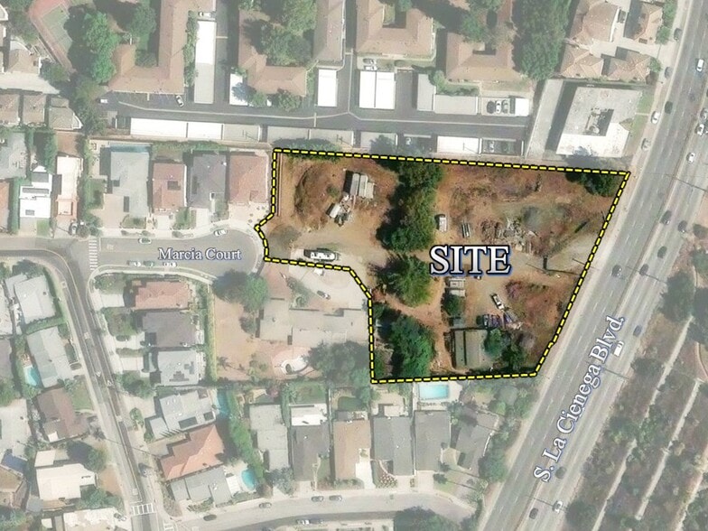
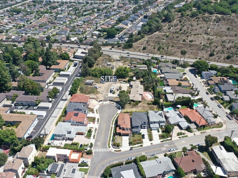
Marcus & Millichap is pleased to offer for sale the property located at 3801 S. La Cienega Blvd. in Culver City, California (APN #4204-010-137). This site consists of an approximately 2.24-acre irregularly shaped parcel of land in the very desirable Blair Hills neighborhood. The surrounding area consists of multi-million dollar homes to the west and south, multi-family residential buildings to the north, and La Cienega Boulevard to the east.
There are currently several older structures on the property but the site is largely vacant. The topography is generally sloping to the northeast with approximately 10 feet of vertical relief across the property. All utilities are located on the west edge of the site at the terminus of the Marcia Court cul-de-sac. Primary access to this site is on the west side from Lenawee Ave through Marcia Court.
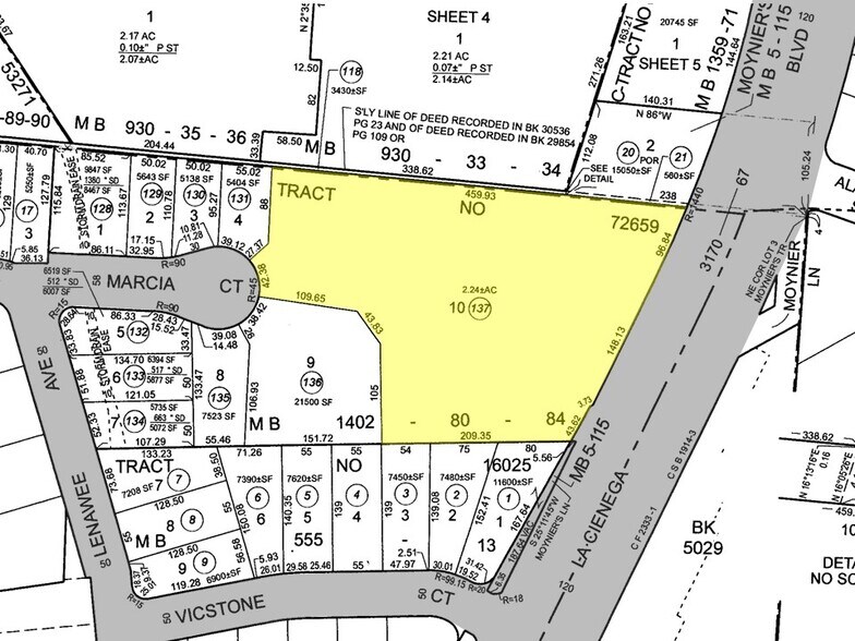
Zoning on the site is PD-14 (Planned District 14) and the General Plan Land Use designation is Medium Density Multifamily which allows for a maximum residential density of 50 du/acre. Culver City Ordinance No. 2016-007 was approved and adopted by the city in August 2016 for the development of Planned District 14. The entirety of the PD-14 planning area encompasses 4.35 acres and consists of one existing SFR, eight new SFRs and the subject property which was set aside for the development of a 90-unit/110-bed senior citizen residential care facility for assisted living and memory care.
The northeast corner of the property falls within a State-designated Alquist-Priolo Earthquake Fault Zone. A geotechnical investigation was conducted in 2015 with results that indicated that active faulting and soil displacement is present in the northeastern portion of the site and a building setback was recommended to prevent the construction of habitable structures over areas of potential surface fault rupture. A geologic-seismic investigation done in 1977 (Scullin Report) concluded that no active faults traversed the site and the risk of ground rupture was considered low to moderate. The amount of land impacted by the fault zone is approximately 44,356 square feet (1.02 acres). This particular part of the site cannot be built on but could be used for parking and site amenities. The remaining buildable area of this site would be approximately 53,118 square feet (1.22 acres).
There are currently several older structures on the property but the site is largely vacant. The topography is generally sloping to the northeast with approximately 10 feet of vertical relief across the property. All utilities are located on the west edge of the site at the terminus of the Marcia Court cul-de-sac. Primary access to this site is on the west side from Lenawee Ave through Marcia Court.
Zoning on the site is PD-14 (Planned District 14) and the General Plan Land Use designation is Medium Density Multifamily which allows for a maximum residential density of 50 du/acre. Culver City Ordinance No. 2016-007 was approved and adopted by the city in August 2016 for the development of Planned District 14. The entirety of the PD-14 planning area encompasses 4.35 acres and consists of one existing SFR, eight new SFRs and the subject property which was set aside for the development of a 90-unit/110-bed senior citizen residential care facility for assisted living and memory care.
The northeast corner of the property falls within a State-designated Alquist-Priolo Earthquake Fault Zone. A geotechnical investigation was conducted in 2015 with results that indicated that active faulting and soil displacement is present in the northeastern portion of the site and a building setback was recommended to prevent the construction of habitable structures over areas of potential surface fault rupture. A geologic-seismic investigation done in 1977 (Scullin Report) concluded that no active faults traversed the site and the risk of ground rupture was considered low to moderate. The amount of land impacted by the fault zone is approximately 44,356 square feet (1.02 acres). This particular part of the site cannot be built on but could be used for parking and site amenities. The remaining buildable area of this site would be approximately 53,118 square feet (1.22 acres).
Faits sur la propriété
1 Lot disponible
Lot
| Prix | 16 820 400 $ CAD | Taille du lot | 2,24 AC |
| Prix par AC | 7 509 107,25 $ CAD |
| Prix | 16 820 400 $ CAD |
| Prix par AC | 7 509 107,25 $ CAD |
| Taille du lot | 2,24 AC |

Moyennement accessible à pied
60/100
Exceptionnellement adapté aux voitures
90/100
Bons transports en commun
70/100
Très accessible en vélo
80/100
Impôts fonciers
| Numéro de lot | 4204-010-137 | Évaluation des bâtiments | 17 840 $ CAD |
| Évaluation du terrain | 371 135 $ CAD | Évaluation totale | 388 975 $ CAD |
Impôts fonciers
Numéro de lot
4204-010-137
Évaluation du terrain
371 135 $ CAD
Évaluation des bâtiments
17 840 $ CAD
Évaluation totale
388 975 $ CAD

1 de 8
Vidéos
Visite extérieure 3D Matterport
Visite 3D Matterport
Photos
Vue depuis la rue
Rue
Carte

Présenté par
3801 La Cienega Blvd - ±2.24-Acre Residential Development Site
Vous êtes déjà membre? Connectez-vous
Hmm, il semble y avoir eu une erreur lors de l’envoi de votre message. Veuillez réessayer.
Merci! Votre message a été envoyé.