Votre courriel a été envoyé.

Land Forming Part of New House Farm, Hurley - Agricultural Land Lot • Ferme • 180 Acres • 4 017 367 $ CAD • Atherstone CV9 2JW

Certaines informations ont été traduites automatiquement.
Faits saillants de l'investissement
- Extensive highway frontage
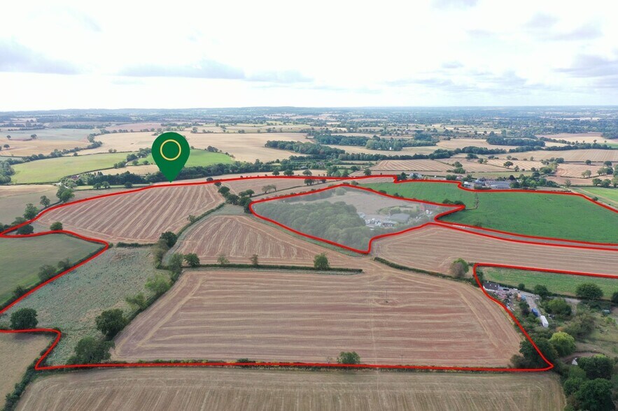
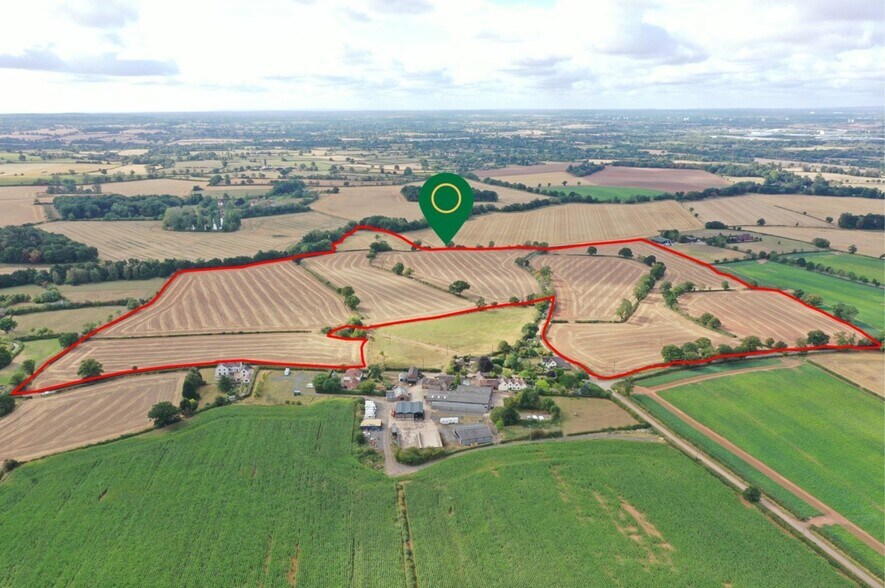
- 100.4 acres (Northern Parcel) & 79.4 acres (Southern Parcel)
- 179.80 acres (72.76 Hectares) or thereabouts
Résumé de l'annonce
What3Words:
Dexter Lane: ///fountain.joys.waggled
(https://what3words.com/fountain.joys.waggled)
Atherstone Lane: ///wedding.seeing.tunnel
(https://what3words.com/wedding.seeing.tunnel)
Southern Block: ///input.snoozing.honestly
(https://what3words.com/input.snoozing.honestly)
& ///upwards.slept.horses
(https://what3words.com/upwards.slept.horses)
The farm is located due south of the village of Hurley. Nearby towns include Atherstone (5.5 miles), Tamworth (8.5 miles) Coleshill (6 miles) and Junction 9 M42 at Dunton Island, Curdworth is 4.5 miles.
When travelling from Atherstone either proceed through the village and turn left into Dexter Lane or at the start of the village turn left into Atherstone Road and then right into Foul End Lane. When travelling from either Coleshill, Tamworth or M42 take the Knowle Hill turning from the Coventry Road and then either turn right into Foul End Lane or continue into the village and turn right into Dexter Lane.
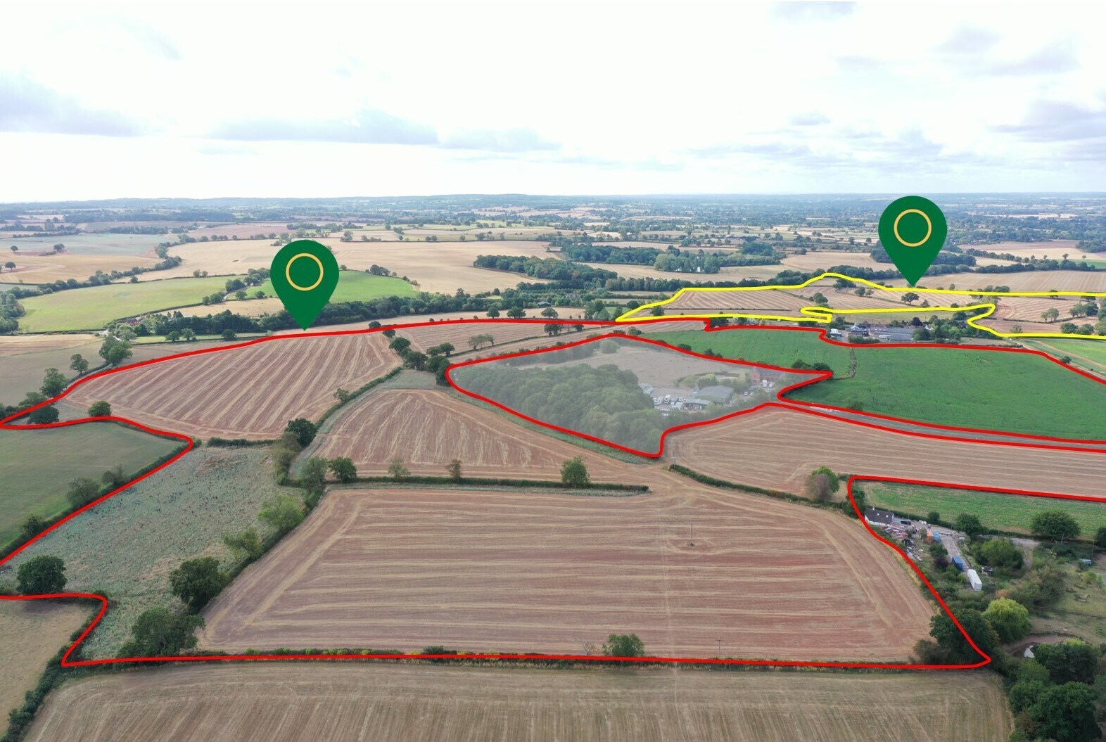
The largest block of the land, some 100.4 acres (40.63 Hectares), extends north and east of the farmhouse, buildings and a small camp site which are not included in the sale. This block has road frontages to Dexter Lane, Foul End Lane and Atherstone Road. In addition, there is a right of way over the driveway which leads to Dexter Grange.
The smaller block of land to the south of the farmhouse comprises approximately 79.4 acres (32.13 hectares), and is accessed from Foul End Lane from two separate road frontages. Additionally, there is a right of way over the track which runs through the neighbouring land, the extension of which then forms part of the subject holding. Also, there is a short right of way on the western side of the pond which is in the neighbour’s property and located in front of the clients’ house and buildings.
Taxes et dépenses d’exploitation (Réel - 2025) Cliquez ici pour accéder à |
Annuel (CAD) | Annuel par AC (CAD) |
|---|---|---|
| Taxes |
-

|
-
|
| Dépenses d’exploitation |
-
|
-
|
| Total des dépenses |
$99,999
|
$9.99
|
Taxes et dépenses d’exploitation (Réel - 2025) Cliquez ici pour accéder à
| Taxes (CAD) | |
|---|---|
| Annuel | - |
| Annuel par AC | - |
| Dépenses d’exploitation (CAD) | |
|---|---|
| Annuel | - |
| Annuel par AC | - |
| Total des dépenses (CAD) | |
|---|---|
| Annuel | $99,999 |
| Annuel par AC | $9.99 |
Faits sur la propriété Sous contrat
| Prix | 4 017 367 $ CAD | Type de propriété | Terrain |
| Type de vente | Propriétaire utilisateur | Sous-type de propriété | Ferme |
| Ancienneté | Pleine propriété | Taille totale du lot | 180,00 AC |
| Nombre de lots | 1 |
| Prix | 4 017 367 $ CAD |
| Type de vente | Propriétaire utilisateur |
| Ancienneté | Pleine propriété |
| Nombre de lots | 1 |
| Type de propriété | Terrain |
| Sous-type de propriété | Ferme |
| Taille totale du lot | 180,00 AC |
1 Lot disponible
Lot
| Prix | 4 017 367 $ CAD | Taille du lot | 180,00 AC |
| Prix par AC | 22 318,71 $ CAD |
| Prix | 4 017 367 $ CAD |
| Prix par AC | 22 318,71 $ CAD |
| Taille du lot | 180,00 AC |
Description
Cette terre productive est susceptible d'attirer les agriculteurs souhaitant agrandir leur exploitation existante. Elle est divisée en enclos pratiques au sein de deux blocs séparés mais adjacents, ce qui la rend propice à l'agriculture arable et/ou à l'élevage. Ces dernières années, la terre a été utilisée pour la culture de céréales, principalement du blé, mais aussi de l'orge, avec des cultures de rotation comprenant du colza, des pois, des pommes de terre et du maïs fourrager, conformément à une politique de rotation recommandée. La terre a été bien cultivée et produit de bonnes récoltes à haut rendement. Du fumier de ferme a été importé d'une ferme voisine. Le terrain est relativement plat du côté ouest et nord-ouest, tandis que le reste du bloc nord descend doucement vers Foul End Lane. Le bloc sud descend également doucement vers le cours du ruisseau le long de la frontière sud. Les limites sont principalement constituées de haies d'aubépine, ce qui s'applique également aux haies internes. Catégorie d'utilisation des terres Grade 3 Sols Principalement limon moyen sur argile; zones d'argile plus lourde dans les fonds de vallée. Zone vulnérable aux nitrates (ZVN) La terre se trouve dans une zone ZVN et est soumise aux restrictions habituelles. Calendrier de culture (2025/26) 19,04 Ha de blé d'hiver (KWS Extase) 10,91 Ha de blé d'hiver (SY Cheer) 15,67 Ha d'orge d'hiver (KWS Tardis) 17,44 Ha pour le maïs fourrager 1,93 Ha de pâturage permanent (Wood Meadow) 1,68 Ha de couverture pour gibier Le reste de la terre comprend des marges environnementales et des pistes. INFORMATIONS GÉNÉRALES ET PRINCIPAUX TERMES DE VENTE MÉTHODE DE VENTE La terre est offerte à la vente par traité privé. Les clients préféreraient vendre la terre en un seul lot, mais une division appropriée sera envisagée. Régimes de paiement de base et d'incitation à l'agriculture durable La terre a historiquement été enregistrée pour les paiements dans le cadre du régime de paiement de base et tous les paiements déliés pertinents pour la terre seront conservés par Mme Pearson. La terre agricole est inscrite dans un programme d'incitation à l'agriculture durable (SFI). À la conclusion de la vente, cet accord sera résilié. Risque d'inondation La terre est dans une zone à faible risque d'inondation. TENURE Pleine propriété avec possession vacante. CLAUSE DE SURPLUS La terre sera vendue sous réserve d'une clause de surplus applicable dans le cas où un permis de construire est obtenu pour tout usage non agricole, horticole ou forestier. Il est prévu que 30 % de toute augmentation de valeur seront requis pendant une période de 25 ans à compter de la date de conclusion de la vente. Les détails complets seront inclus dans la documentation du contrat. VENTE DES RÉCOLTES La terre a été ensemencée avec du blé d'hiver et de l'orge d'hiver, avec du maïs fourrager prévu pour le printemps 2026. L'acheteur(s) devra payer le coût des semences, des engrais, des pulvérisations appliquées et des cultures selon la facture du prestataire. Une prime d'amélioration peut être requise, selon la date d'achat et déterminée par l'agent des vendeurs. L'acheteur(s) ne sera pas facturé pour les valeurs attribuées aux engrais artificiels non épuisés ou à la chaux qui ont été appliqués à la terre. SERVICES Auparavant, certains champs contenaient des abreuvoirs. Les acheteurs nécessitant la réinstallation d'un approvisionnement en eau devraient faire leurs propres démarches auprès de Severn Trent Water Plc. SEVERN TRENT WATER https://www.stwater.co.uk/building-and-developing/overview/new-connections/new-water-connections/ AUTORITÉ LOCALE Conseil de l'arrondissement de North Warwickshire The Council House South Street Atherstone CV9 1DE Tel: 01827 715341 www.northwarks.gov.uk SERVITUDES, DROITS DE PASSAGE, COVENANTS RESTRICTIFS ET DROITS DE PASSAGE La propriété est offerte sous réserve et avec tous les avantages de tout accord de servitude, servitudes et droits de passage qui peuvent exister sur celle-ci et de tout autre droit affectant la propriété, indépendamment de leur mention dans ces détails. Il y a plusieurs sentiers publics reliés qui traversent la terre dans le bloc nord. Il y a un chemin de bride qui longe la frontière sud-ouest de la terre sous Foul End Lane et un autre sentier public. DROITS MINÉRAUX, SPORTIFS ET DE BOIS Les droits sportifs et de bois seront transférés avec le titre de pleine propriété. Les mines et minéraux ainsi que les pouvoirs auxiliaires sont exceptés avec des dispositions pour une compensation en cas de dommage. CLÔTURES ET LIMITES Les vendeurs croient que toutes les limites relèvent de la propriété de la terre. Cependant, les acheteurs potentiels devraient supposer que la présomption habituelle quant à la propriété et à l'entretien des limites s'appliquera, sauf si les conditions de vente prévoient le contraire.


Présenté par
Land Forming Part of New House Farm, Hurley - Agricultural Land
Hmm, il semble y avoir eu une erreur lors de l’envoi de votre message. Veuillez réessayer.
Merci! Votre message a été envoyé.