Kissimmee Land for Sale - Osceola Outlying
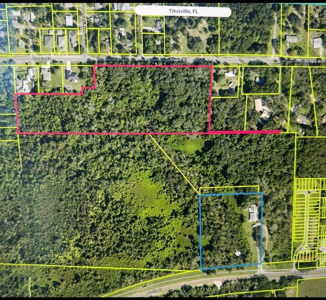
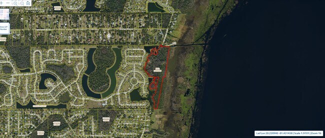
Great opportunity for the smart developer looking to maximize their assets and with a vision of something beautiful while preserving the ecosystem and the nature. 5 Acres already zoned as residential and another 11 acres zoned as rural land, (There is a process called entitlement that requires a zoning change subject to an approved project), if you need more information contact the listing agent directly. This is the gem you were looking for? also 14 acres of submerged land water front directly into the lake, the total sale include all the buildable land plus the submerged land for a total of 29 acres, all the data is available from tax records and the zoning department. This is a big lake where navigation is allowed, there is a public road and a public boat ramp on the side of the property and also a dock or piers can be build here to build a private marina. Amazing "realistic" and reasonable asking price, way below the average market value per acre in the area (around $350,000 to $400,000 in comparable). Seller is motivated and the price is the best signal to understand this fact. Not a distress sale, foreclosure or mistakes here. Just priced right for a fast sale. Easy access while main infrastructure is at a reasonable access, such as water, sewer, public roads, and electricity. This is a sale that should move fast under the current land demand in this area. Seller is considering a join venture under the right terms or seller financing. Contact the listing agent for more details.
Zoning: PD—Planned Development
The parcel is reported as zoned PD, Planned Development. Osceola County describes PD zoning as a customized district intended to permit integrated development through an approved development plan, potentially containing residential, commercial, recreational, or mixed uses.
This is important: PD is not a general authorization for every one of those uses. The actual allowable uses, density, unit count, building height, setbacks, open space, access points and development phases are established by the specific PD ordinance, approved concept plan and subsequent amendments applicable to this property.
Osceola County itself directs owners of PD property to contact its Zoning Department because additional, property-specific rules apply. Osceola County PD District guidance
Future land use:
We conclusively authenticate the parcel’s exact Future Land Use Map designation from the County’s public GIS interface. Yet and because the PD Zoning is complex and requires a full review of the proposed project by the county and the city, I would not market a specific Future Land Use Map(FLUM) category as confirmed until any future project get approval. The Osceola County issues a zoning/land-use verification letter already giving us a verification of PD classification.(Planned Development-Some time called Planed Development District)
The MLS language stating approximately:
• 5 acres “residential”
• 10.66 acres “rural” (Subject to zoning change after review of the proposed project to get entitlements)
• 13.64 acres “other” ( This land is considered submerged land and can be used for recreational, marinas or preservation areas.
appears more consistent with property-appraisal land classifications or listing descriptions than a reliable determination of adopted Future Land Use. Those acreage classifications should not be treated as development entitlements.
Realistic new-development possibilities
Subject to the PD documents and FLUM designation, the parcel may be considered for:
• Single-family residential development
• Townhomes or another attached residential format
• Multifamily residential
• Neighborhood commercial or mixed use
• Waterfront recreation, marina or community-access improvements
• Conservation/open-space components
These are potential development concepts, not presently verified entitlements. Commercial and multifamily proposals should not be advertised as “approved” or “by right” based only on the PD label or the MLS possible-use fields.
A new development may require some combination of:
1. PD amendment or substantial-change approval
2. Future Land Use Map amendment, if the proposal exceeds the current FLUM
3. Preliminary subdivision plan and final plat.
4. Site-development-plan approval
5. Transportation concurrency or mobility analysis
6. Utility-capacity and connection approvals
7. Stormwater and floodplain approvals
8. Wetland delineation and environmental permitting
9. Lake Tohopekaliga shoreline and agency approvals
10. Confirmation of legal road access and emergency access
Because much of the gross acreage appears associated with the Lake Tohopekaliga shoreline, the net developable upland acreage could be materially smaller than 29.3 acres. A boundary/topographic survey, wetland delineation, flood analysis and environmental assessment are essential before estimating unit yield.
Recommended marketing language
For brokerage or offering-material purposes, I recommend:
“Approximately 29.3 gross acres currently reported as Planned Development (PD). Potential development uses and density are subject to the applicable PD development plan, Future Land Use designation, environmental constraints and approval by Osceola County and other governmental agencies. Buyers must independently verify all zoning, land use, utilities, access, density and development entitle