Las Vegas Land for Sale - Central East Las Vegas
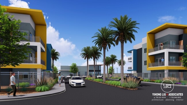
167-Unit Apartment Development Opportunity
6.7 Acres | Las Vegas, Nevada
APN Number: 161-27-802-002
Over $800,000 in soft costs have already been incurred and paid and are included in the asking price for the fully approved 167-unit development.
Seller will consider owner carry at the right terms.
R4 Entitlement extended to 9/2026 for the 167-Unit Apartment Development; however, you can potentially do Corridor Mixed-Use “CM” with density allowing up to 18 du/ac "or", Commercial General “CG" due to; Planned Land Use and Zoning Classification.
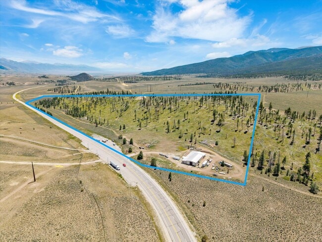
Presenting a premier development opportunity in Las Vegas: 6.7 acres fully entitled for a 167-unit apartment complex - Entitlement Extended to 9/21/206
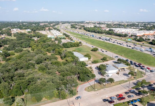
on Boulder Highway with approximately 1,000 feet of high-visibility frontage
This 6.7-acre site in Las Vegas, fully entitled for a 167-unit apartment complex, is truly a shovel-ready opportunity with architectural and civil drawings already complete.
Developers can break ground quickly, with an early grading permit obtainable in as little as three weeks, dramatically accelerating the timeline to construction and revenue generation.
Positioned along the high-visibility Boulder Highway corridor, the site benefits from strong daily traffic exposure with an estimated 24,000 to 33,000 Vehicles Per Day (VPD), ensuring exceptional visibility and long-term value for a multifamily
Perfectly positioned in a thriving market with strong rental demand, this property offers developers a rare chance to bring a high-density multifamily project to one of the fastest-growing cities in the U.S. Located near major employers, retail, dining, and entertainment, the site combines convenience with lifestyle appeal, ensuring long-term tenant attraction and retention.
167-Unit Apartment Development Opportunity
6.7 Acres | Las Vegas, Nevada
APN Number: 161-27-802-002
Over $800,000 in soft costs have already been incurred and paid and are included in the asking price for the fully approved 167-unit development.
Shovel-Ready & Prime Location
Seller will consider owner carry at the right terms.
Currently Entitlement: R4, 167-Unit Apartment Development -
Planned Land use: Corridor Mixed-Use “CM” with density allowing up to 18 du/ac -
Zoning Classification: Commercial General “CG” -
• 167-unit apartment complex fully entitled on 6.7 acres
• Architectural & civil drawings complete – save time and costs
• Early grading permit obtainable in as little as 3 weeks – start building fast
• Positioned in one of the fastest-growing U.S. cities with strong rental demand
Positioned along the high-visibility Boulder Highway corridor, the site benefits from strong daily traffic exposure with an estimated 24,000 to 33,000 Vehicles Per Day (VPD), ensuring exceptional visibility and long-term value for a multifamily development.
Unmatched Advantages
• Accelerated timeline – approvals and design work in place
on Boulder Highway with approximately 1,000 feet of high-visibility frontage
• High-demand multifamily market driven by population growth and a booming job sector
• Proximity to employment centers, retail, dining, and entertainment ensures strong tenant appeal
• Minimized risk, maximized potential – turnkey development ready to launch
Why Invest Here?
Las Vegas continues to thrive as a hub for business, tourism, and new residents, creating a surging demand for modern, well-located housing. With entitlements, drawings, and fast-track grading approvals already secured, this project offers developers a rare, high-value opportunity to deliver a profitable multifamily community in record time.
For quicker response, please text or email
Listing Broker has interest in Property.
Seller may pay a 2% cooperating commission to Buyer’s licensed Nevada real estate broker, if applicable, pursuant to a fully executed separate written commission agreement.
Disclaimer: All information regarding 6230 Boulder Hwy, Las Vegas, NV 89122 is provided strictly AS-IS for marketing only and is not guaranteed. Seller and Seller’s broker make NO representations or warranties. Buyer and brokers waive reliance, assume all verification risk, and agree to indemnify, release, and hold harmless Seller and Seller’s broker from any and all claims arising from use of this information.